Understanding the Geography of Morocco’s Atlas Mountains
Morocco is home to one of North Africa’s most impressive natural landscapes: the Atlas Mountains. Stretching across the country from southwest to northeast, these mountain ranges shape Morocco’s climate, culture, agriculture, and tourism.
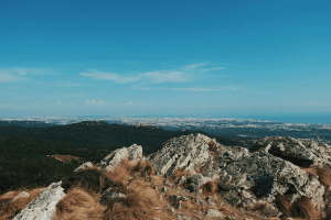
Travelers, researchers, and geography enthusiasts often study a map of morocco atlas mountains to understand how the terrain influences nearby cities, valleys, and deserts. The mountain system creates dramatic scenery that ranges from snow-covered peaks to fertile valleys and dry plateaus.
The Atlas Mountains are divided into three major sections: the High Atlas, the Middle Atlas, and the Anti-Atlas. Each region has distinct geographic features, elevations, and environmental conditions. Together, they form a natural barrier between the Atlantic coast, inland plains, and the Sahara Desert. Understanding the geography of these mountains provides insight into Morocco’s environmental diversity and historical development.
The Formation of the Atlas Mountains
The Atlas Mountains were formed millions of years ago due to tectonic plate movements between the African and Eurasian plates. Geological activity pushed the land upward, creating rugged peaks, valleys, and deep gorges. Over time, erosion shaped the landscape into the dramatic formations visible today.
The High Atlas contains the tallest mountains in North Africa, including Mount Toubkal, which rises to more than 4,000 meters above sea level. Snowfall is common during winter in the higher elevations, making the region important for water resources across Morocco. Rivers originating from the mountains support agriculture and provide water to nearby communities.
When examining a map of morocco atlas mountains, it becomes clear that the ranges extend over a vast distance. Their position affects wind patterns and rainfall distribution throughout the country. Coastal regions receive more moisture, while southern areas beyond the mountains become increasingly dry and desert-like.
The High Atlas Region
The High Atlas is the most famous and dramatic section of the mountain chain. It stretches across central Morocco and includes steep cliffs, narrow valleys, and traditional Berber villages. Many tourists visit this region for trekking, hiking, and mountain climbing.
Mount Toubkal, located near Marrakesh, attracts adventurers from around the world. The surrounding terrain includes rocky slopes, alpine meadows, and winding mountain passes. Villages in the High Atlas are often built from local stone and clay, blending naturally into the environment.
The geography of the High Atlas also plays a major role in agriculture. Meltwater from mountain snow feeds irrigation systems that support crops such as olives, walnuts, apples, and barley. Terraced farming is common in valleys where flat land is limited.
Climate conditions in the High Atlas vary depending on altitude. Lower areas experience warm summers and mild winters, while higher elevations can become extremely cold with heavy snow. These differences create diverse ecosystems that support unique plants and wildlife.
The Middle Atlas Region
North of the High Atlas lies the Middle Atlas, known for its forests, lakes, and gentler mountain landscapes. Compared to the rugged High Atlas, this region has more rolling hills and fertile plateaus. Cedar forests dominate parts of the Middle Atlas and provide habitat for the endangered Barbary macaque.
The Middle Atlas experiences cooler temperatures and higher rainfall than many other parts of Morocco. Because of this climate, the region supports farming communities and grazing lands. Cities such as Ifrane and Azrou are located within this mountainous area and are famous for their cooler weather and scenic beauty.
A detailed map of morocco atlas mountains often highlights the Middle Atlas as an important ecological zone. Rivers and streams flowing from these mountains contribute to Morocco’s freshwater supply. Lakes in the region also attract birds and wildlife, making the area significant for biodiversity.
The landscape changes noticeably between seasons. Spring brings green valleys and blooming flowers, while winter transforms higher elevations into snowy landscapes. These seasonal changes make the Middle Atlas attractive for both domestic and international tourism.
The Anti-Atlas Region
The Anti-Atlas lies in southern Morocco and differs greatly from the greener northern ranges. This region is older geologically and has lower elevations, rocky terrain, and arid conditions. The Anti-Atlas serves as a transition zone between the mountain systems and the Sahara Desert.
The landscape is marked by dry valleys, unusual rock formations, and sparse vegetation. Despite the harsh environment, local communities have adapted through oasis agriculture and traditional water management systems. Almond trees, argan trees, and date palms are common in certain valleys.
Travelers exploring a map of morocco atlas mountains may notice how the Anti-Atlas connects mountainous terrain with desert regions. This geographic relationship creates striking contrasts between fertile oasis settlements and barren desert landscapes.
The Anti-Atlas also contains valuable mineral resources, and mining has been part of the regional economy for many years. In addition, the area is rich in cultural heritage, with ancient kasbahs and Amazigh traditions continuing to shape local identity.
The Influence on Climate and Water Resources
The Atlas Mountains have a powerful effect on Morocco’s climate. Moist air from the Atlantic Ocean rises when it reaches the mountains, producing rainfall and snowfall. This process supports forests, rivers, and agricultural zones on the northern slopes.
On the southern side, the mountains block much of the moisture, creating drier conditions closer to the Sahara Desert. This contrast explains why Morocco contains both green valleys and desert landscapes within relatively short distances.
Water from the mountains is essential for millions of people. Rivers originating in the Atlas Mountains provide irrigation for farms and drinking water for cities. Dams and reservoirs built along these rivers help manage water supplies during dry periods.
Climate change has increased concerns about shrinking snowpack and changing rainfall patterns. Reduced snowfall could affect agriculture and water availability in the future, making environmental conservation increasingly important.
Cultural and Economic Importance
The Atlas Mountains are not only geographically significant but also culturally important. Amazigh communities have lived in these mountains for centuries, maintaining distinct languages, architecture, and traditions. Their villages often reflect the surrounding environment, using locally sourced materials and traditional building techniques.
Tourism has become a major economic activity in many mountain regions. Visitors come for trekking, skiing, photography, and cultural experiences. Markets in mountain towns sell handmade carpets, pottery, jewelry, and textiles that reflect local craftsmanship.
Agriculture remains another key part of life in the Atlas Mountains. Farmers grow crops suited to mountain climates and use irrigation systems developed over generations. Livestock grazing is also common in upland areas.
Anyone studying a map of morocco atlas mountains can better appreciate how geography influences settlement patterns, trade routes, and transportation networks. Roads often follow valleys and mountain passes, connecting isolated communities with larger cities.
Conclusion
The Atlas Mountains are one of Morocco’s defining geographic features. From the snow-covered peaks of the High Atlas to the forested landscapes of the Middle Atlas and the rocky terrain of the Anti-Atlas, each region contributes to the country’s environmental diversity.
These mountains shape climate patterns, provide essential water resources, support agriculture, and preserve unique cultural traditions. Their influence extends far beyond the mountain valleys themselves, affecting the economy, ecosystems, and daily life throughout Morocco.